Syningen 1047 m n.p.m.
Ostatnio wspominałem, że planując wypad na Hydalshjallen, miałem w zanadrzu jeszcze jedną krótką wycieczkę do odbycia. Była to zaledwie 3 kilometrowa trasa na szczyt Syninngen (1047 m n.p.m.). Górka ta znajduje się u wylotu doliny Hemsedal, blisko miasta Gol. Wg opisu szlaku na stronie Ut.no, wejście na Syningn zajmuje około godziny, zakładałem zatem krótki i lekki spacerek a potem kilkugodzinny powrót na kwaterę.
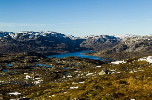
Po mroźnym marszu na Hydalshjallen, wstąpiłem do sklepu centrum Hemsedal po jakiś świeży prowiant i zaopatrzony w norweskie przysmaki udałem się w kierunku kolejnego celu wyprawy. Jadąc drogą 52 na południe, wzdłuż rzeki Hemsil, wypatrywałem zjazdu na Grønli, który miał mnie zaprowadzić na parking przy szlaku. Odnalazłem szlak i wbiłem się w boczną drogę, która zakosami poprowadziła mnie w górę. Kilka zakrętów dalej odbiłem w lewo w kolejną boczną, tym razem nieutwardzoną drogę, gdzie za wjazd trzeba było zapłacić 60 kr. W końcu dotarłem na miejsce. A gdy tylko wysiadłem z auta, aż mnie zatkało. Jeszcze nie byłem na szlaku, a widoki już były obłędne.


Po skonsumowaniu pyszności z marketu i naklikaniu miliarda zdjęć, czas było ruszać. Odnalazłem jakąś tablicę z mapką okolicy i zaznaczonymi trasami oraz możliwe kierunki wędrówki. Niestety na żadnym nie napisano nazwy szczytu, na który zmierzałem. Musiałem iść na wyczucie, jako, że nie miałem ze sobą żadnej wydrukowanej zawczasu mapki, a internet w telefonie strzelił właśnie focha. Poszedłem w lewo, ale po kilkuset metrach uznałem, że jednak lepiej będzie wrócić i wybrać drogę na prawo.
Maszerowałem jakiś czas, usilnie starając się nie wpaść w jakąś kałużę, teren był bowiem dość podmokły. Przez jakiś czas towarzyszył mi widok ośnieżonych szczytów w dolinie Hemsedal na północy. Potem dotarłem do szutrowej drogi i na kolejnym skrzyżowaniu skręciłem w lewo. Słońce ładnie świeciło i szło się całkiem przyjemnie, dopóki nie zorientowałem się, że już przecież powinienem być gdzieś w okolicy szczytu. Wyciągnąłem komórkę. Internet w końcu zaskoczył i mogłem uruchomić aplikację Ut.no. Okazało się, że po raz kolejny źle wybrałem drogę na skrzyżowaniu i zamiast iść w kierunku góry, tylko się od niej oddalam. Trzeba było zawrócić.

Po drodze na szczyt błądziłem jeszcze ze dwa razy i trasę, która powinna mi zająć w sumie dwie godziny, skończyłem w ponad cztery. Sama górka nie okazała się wysoka. Poziom, z którego się startuje to już około 1000 m n.p.m., wystarczyło więc wspiąć się jakieś kilkadziesiąt metrów, by sięgnąć szczytu.
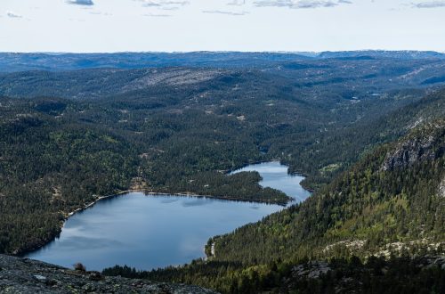
Widoki na góry Hemsedal nie odbiegały od tego co zauważyłem z parkingu, choć wydawały się jeszcze bardziej niesamowite.


Wracając do auta, nie wyłączałem już komórki, co chwila zerkając na mapę, aby już więcej nie skręcić w niewłaściwą drogę. Okolicę przecina sieć dróg i ścieżek, a oznaczenia szlaków poustawiano dość skąpo, tak więc o pomyłkę nie tak trudno. Na szczęście udało mi się już bez przeszkód powrócić na parking, zapakować się do samochodu i wrócić do siebie.
Recently I mentioned that when planning a trip to Hydalshjallen, I had another short trip to take. It was only a 3 km route to the Syninngen peak (1047 m a.s.l.). This hill is located at the end of the Hemsedal Valley, close to the city of Gol. According to the description of the trail on the Ut.no website, it takes about an hour to get to Syningn, so I assumed a short and easy walk and then returned home for several hours.


After a frosty march on Hydalshjallen, I entered the Hemsedal center store for some fresh lunch and equipped with Norwegian sweet buns, I headed towards the next destination point of my trip. Driving along Route 52 south, along the Hemsil River, I was looking for the exit at Grønli, which was to lead me on porking next to the trail. Finding this road is easy but then you have to turn the to the other, this time gravel road and pay a toll (60 kr). And after few next kilometers you will get to the right place. And as soon as I got out of the car, I lost my breath. I haven’t been on the trail yet, and the views from this point have been insane.


After consuming the sweets from the market and clicking on a billion photos, it was time to move. I found a board with a map of the area and marked routes, and possible hiking directions. Unfortunately none of them wrote the name of the summit I was heading to. Unfortunately I didn’t have any map printed earlier, and the internet on my phone didn’t work. I turned left, but after a few hundred meters I thought that it would be better to go back and choose the right path.
I marched for some time, trying hard to not fall into a puddle, because the area was quite wet. For some time I was accompanied by a view of snowy peaks in the Hemsedal Valley on the north. Then I got to the gravel road and turned left at the next crossroad. The sun was shining nicely and it was quite pleasant until I realized that I should be somewhere around the summit. I took out my cell phone. I’ve got the Internet finally this time and I could run the Ut.no application. It turned out that once again I had chosen the wrong way at the crossroad and instead of going towards the mountain, I was moving away from it. I had to turn back.
Before I get to the place, I miss the right path another two times, but finally I place my feet on the summit.
Views of Hemsedal are not different from what I noticed from the parking lot, but they seemed even more amazing.


Returning to the car, I did not turn off the cellphone, to check map constaintly. I didn’t want to turn the wrong way again. The area is crossed by a network of roads and paths, and the markings on the trails are quite scarce, so it is not that difficult to make a mistake. Fortunately, I managed to return to the parking lot without any additional adventures. I packed myself to the car and return to my place.