Powrót na Kjellesviknuten (575m n.p.m.)
Nie sądziłem, że tak szybko wrócę na tę górę. W przeszłości wchodziłem na nią kilkakrotnie, a ostatni raz opisałem tutaj. Wędrówkę zaproponował Maniek, z którym kiedyś odbyliśmy świetną wycieczkę na Øktarenuten i Døldaren. To miał być popołudniowy, parogodzinny wypad. Pogoda była idealna, dużo lepsza niż to co spotkało mnie dwa dni wcześniej na Lammanuten. Trochę co prawda wiało, ale najważniejsze, że nie padało.
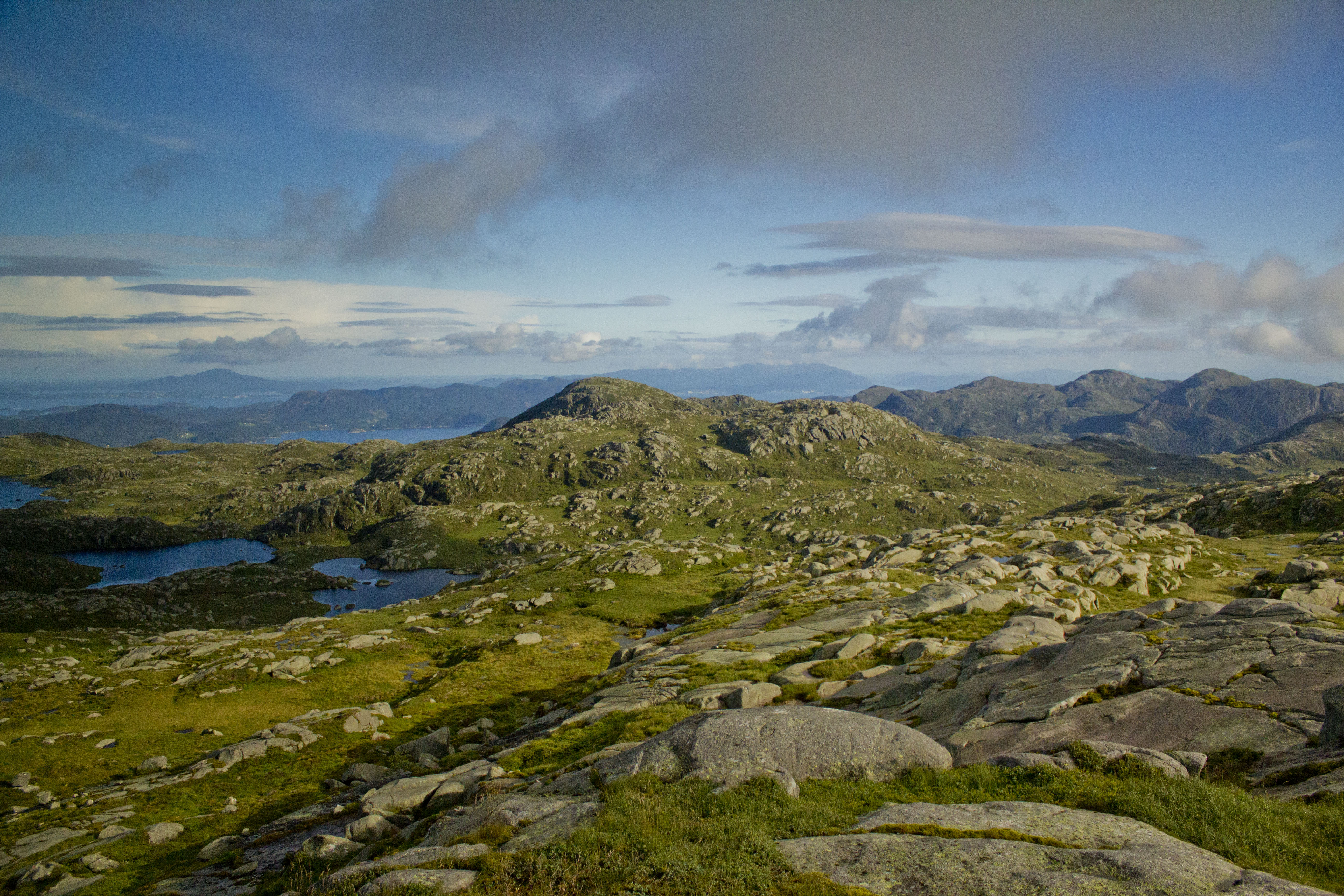
Aby dostać się na szlak należy odbić z drogi E134 w kierunku wioski Utbjoa i jadąc wzdłuż fiordu Ølsjoen, wypatrywać niewielkiej tabliczki kierującej na Vakadalen. Lepszym punktem orientacyjnym jest duża tablica z reklamą działek na sprzedaż. Przy niej trzeba skręcić w lewo i po kilkudziesięciu metrach szutrowej drogi w prawo na bezpłatny parking. Na parkingu znajduje się tablica z informacją na temat trasy na Kjellesviknuten. Stąd szeroka droga prowadzi najpierw do doliny Vakadalen, a następnie po odbiciu na północ, na szczyt Kjellesviknuten. Przy końcu drogi już czeka tabliczka wskazująca zmianę kierunku i kolejny etap trzeba przebyć wspinając się wąską ścieżką biegnącą w górę zakosami przez las. Nie trwa to na szczęście zbyt długo i wychodząc zza linii drzew możemy już cieszyć się nie tylko bardziej płaskim terenem ale i widokami. Panorama obejmuje miasteczka Ølen i Etne oraz krzyżujące się fiordy Ølsjoen i Etenfjorden. W dodatku możemy podziwiać mnóstwo okolicznych szczytów. Z tego miejsca do końca wędrówki pozostało góra 30 minut.
Krajobraz wydawał mi się diametralnie inny od tego, co zapamiętałem z mojej poprzedniej wizyty na tym szlaku. Wtedy ścieżkę i wszystko wokół pokrywał śnieg i droga na szczyt była nie lada wyzwaniem. Teraz szło się o niebo łatwiej. Wydeptana ścieżka była doskonale widoczna i tylko coraz silniejsze zimne podmuchy wiatru burzyły sielskość wycieczki. Przed ostatnim podejściem założyłem na siebie kurtkę, zdając sobie sprawę, że tam wyżej nie będzie już żadnej ochrony przed wiatrem, i może on być dużo mocniejszy. Nie pomyliłem się. Wiało, że aż palce kostniały z zimna. Ale za to widoki okazały się obłędne.
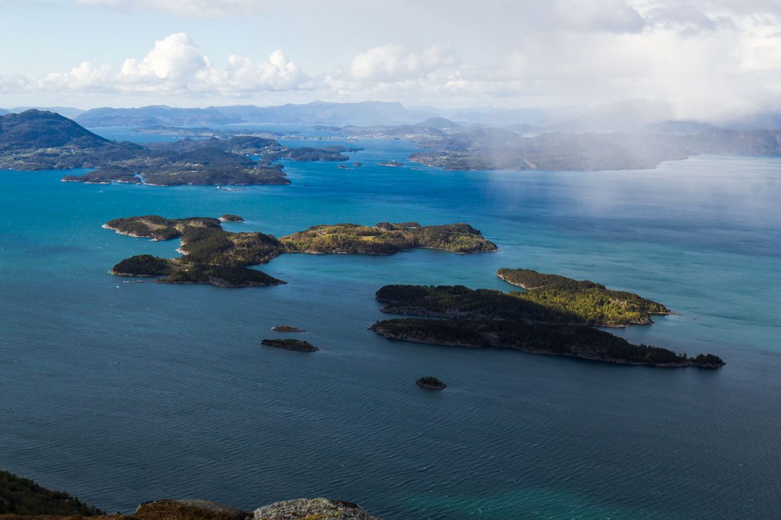
Już zapomniałem jak pięknie jest na Kjellesviknuten. Pod górą spotykają się wody aż czterech fiordów (Ølsjoen, Etenfjorden, Bjoafjorden i Skånevikfjorden), tworząc szeroki akwen, od północy graniczący z samym Hardangerfjordem. Na tej pokaźnej przestrzeni dopełnieniem obrazu są wyspy, z których najbliższe Romsa i Glopsøya robią z tej wysokości (575m n.p.m.) piorunujące wrażenie. Kjelesviknuten znajduje się na wprost wejścia do Etnefjordu, zatem ze szczytu widać jak na dłoni przestrzeń aż do samego Etne. Przy odpowiednich warunkach dojrzeć można także ogromną śniegową czapę, pokrywającą lodowiec Folgefonna na północnym wschodzie. Tego dnia jednak chmury przesłoniły nam to zjawisko.
Na szczyt można wejść w półtorej godziny, co czyni Kjellesviknuten stosunkowo łatwym i popularnym wśród okolicznych mieszkańców celem wędrówek. Niesamowite widoki ze szczytu to dodatkowa motywacja by choć raz pokonać tę trasę. Polecam każdemu, kto będzie kiedyś w okolicy z zapasem około 3 godzin.


I didn’t think I would come back to this mountain so soon. In the past I have climbed it few times and the last time I described here. The trip was suggested by Maniek, with whom we once had a great hiking trip to Øktarenuten and Dørldaren. It was supposed to be an afternoon, couple-hour trip. The weather was perfect, much better than what happened to me two days earlier on Lammanuten. It was a little windy, but most importantly it wasn’t raining.
To get on the trail, turn from E134 road towards the village of Utbjoa and drive along the Ølsjoen fjord, looking for a small sign pointing to Vakadalen. A better landmark is a large billboard with advertising plots for sale. Next to it, turn left and after several dozen meters of gravel road, turn right onto a free parking lot. The parking has a board with information about the route to Kjellesviknuten. From here, a wide road leads first to the Vakadalen Valley and then on the northern side of the valley you can find the road to the Kjellesviknuten peak. At the end of the road there is a sign indicating a change of direction and the next stage you must climb along a narrow path running upwards through the woods. Fortunately, it doesn’t take too long and we can enjoy not only the flatter terrain but also the views from behind the tree border. The panorama covers the towns of Ølen and Etne and the crossing of the Ølsjoen and Etenfjorden fjords. In addition, we can admire the many surrounding peaks. From this place, up to 30 minutes remain until the end of the journey.
The landscape seemed radically different to what I remembered from my previous visit here. Then the path and everything around was covered with snow and the way to the top was a challenge. Now it was much easier. The trodden path was perfectly visible and only the increasingly strong cold gusts of wind destroyed the idyll of the trip. Before the last hill I put on a jacket, realizing that there would be no protection against the wind up there, and it could be much stronger. I was not wrong. The wind make my fingers freezing very quickly. But the views turned out to be insane.
I have already forgotten how beautiful it is on Kjellesviknuten. Under the mountain meet the waters of four fjords (Ølsjoen, Etenfjorden, Bjoafjorden and Skånevikfjorden), forming a wide area, from the north bordering the Hardangerfjord itself. In this large space, the picture is complemented by islands, from which the nearest Romsa and Glopsøya make a thundering impression from this height (575 m a.s.l.). Kjelesviknuten is located directly opposite the entrance to Etnefjord, so from the top you can see the space up to Etne. With the right conditions, you can also see a huge snow cap covering the Folgefonna glacier in the northeast. On this day, however, clouds obscured this phenomenon.
You can reach the summit in an hour and a half, which makes Kjellesviknuten a relatively easy and popular hiking destination for local residents. Amazing views from the summit are an additional motivation to overcome this route at least once. I recommend it to anyone who will ever be in the area with a reserve of about 3 hours.